美国宇航局将发射首颗全球水勘测卫星
科技新闻 2022-12-16 19:43网络整理lllnews.com
美国太空探索技术公司的一枚火箭将于周五早上从加州发射,搭载一颗美法卫星,旨在对地球表面水域进行首次全球调查,为气候变化的机制和后果提供新的线索。
A SpaceX rocket was due for launch from California early on Friday carrying a U.S.-French satellite designed to conduct the first global survey of Earth's surface waters, shedding new light on the mechanics and consequences of climate change.
A SpaceX rocket was due for launch from California early on Friday carrying a U.S.-French satellite designed to conduct the first global survey of Earth's surface waters, shedding new light on the mechanics and consequences of climate change.
根据美国宇航局的合同,亿万富翁埃隆·马斯克的商业发射公司拥有和运营的猎鹰9号火箭,定于太平洋标准时间凌晨3点46分(格林尼治标准时间1点46分)从洛杉矶西北约170英里(275公里)的范登堡美国太空部队基地发射。
The Falcon 9 rocket, owned and operated by billionaire Elon Musk's commercial launch company under NASA contract, was set for blastoff at 3:46 a.m. PST (1146 GMT) from Vandenberg U.S. Space Force Base, about 170 miles (275 km) northwest of Los Angeles.
The Falcon 9 rocket, owned and operated by billionaire Elon Musk's commercial launch company under NASA contract, was set for blastoff at 3:46 a.m. PST (1146 GMT) from Vandenberg U.S. Space Force Base, about 170 miles (275 km) northwest of Los Angeles.
周四的天气预报预测了发射的有利条件,美国宇航局的发射服务团队正在管理。美国宇航局表示,在检查人员检测到火箭9个主发动机中的两个有水分后,倒计时从周四推迟了24小时,但经过进一步分析,问题已经解决。
Weather forecasts on Thursday predicted favorable conditions for liftoff, which a NASA launch services team is managing. The countdown was postponed from Thursday for 24 hours after inspectors detected moisture in two of the rocket's nine main engines, but the issue was resolved following further analysis, NASA said.
Weather forecasts on Thursday predicted favorable conditions for liftoff, which a NASA launch services team is managing. The countdown was postponed from Thursday for 24 hours after inspectors detected moisture in two of the rocket's nine main engines, but the issue was resolved following further analysis, NASA said.
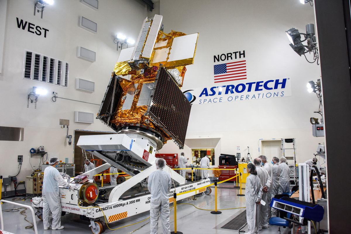
该火箭的有效载荷是地表水和海洋地形卫星(SWOT),它结合了先进的微波雷达技术,可以收集全球90%以上的海洋、湖泊、水库和河流的高清测量数据。
The rocket's payload, the Surface Water and Ocean Topography satellite, or SWOT, incorporates advanced microwave radar technology to collect high-definition measurements of oceans, lakes, reservoirs and rivers over 90% of the globe.
The rocket's payload, the Surface Water and Ocean Topography satellite, or SWOT, incorporates advanced microwave radar technology to collect high-definition measurements of oceans, lakes, reservoirs and rivers over 90% of the globe.
研究人员说,这些数据来自每21天对地球至少两次的雷达扫描,将用于增强海洋环流模型,支持天气和气候预报,并帮助管理干旱地区稀缺的淡水供应。
The data, compiled from radar sweeps of the planet at least twice every 21 days, will be used to enhance ocean-circulation models, bolster weather and climate forecasts and aid in managing scarce freshwater supplies in drought-stricken regions, researchers say.
The data, compiled from radar sweeps of the planet at least twice every 21 days, will be used to enhance ocean-circulation models, bolster weather and climate forecasts and aid in managing scarce freshwater supplies in drought-stricken regions, researchers say.
这颗suv大小的卫星的部件主要由洛杉矶附近的美国宇航局喷气推进实验室(JPL)和法国航天局CNES建造。
Components of the SUV-sized satellite were built primarily by NASA's Jet Propulsion Laboratory (JPL) near Los Angeles and the French space agency CNES.
Components of the SUV-sized satellite were built primarily by NASA's Jet Propulsion Laboratory (JPL) near Los Angeles and the French space agency CNES.
美国航天局在加拿大和英国的同行的贡献下发展了近20年,SWOT是国家研究委员会列出的NASA在未来十年应该开展的15个项目之一。
Nearly 20 years in development by the U.S. space agency with contributions from its counterparts in Canada and Britain, SWOT was one of 15 missions listed by the National Research Council as projects NASA should undertake in the coming decade.
Nearly 20 years in development by the U.S. space agency with contributions from its counterparts in Canada and Britain, SWOT was one of 15 missions listed by the National Research Council as projects NASA should undertake in the coming decade.
气候临界点?
CLIMATE TIPPING POINT?
CLIMATE TIPPING POINT?
该任务的一个主要任务是探索海洋是如何吸收大气热量和二氧化碳的,这一过程自然地调节了全球温度,并有助于最大限度地减少气候变化。
One major thrust of the mission is to explore how oceans absorb atmospheric heat and carbon dioxide in a process that naturally regulates global temperatures and has helped to minimize climate change.
One major thrust of the mission is to explore how oceans absorb atmospheric heat and carbon dioxide in a process that naturally regulates global temperatures and has helped to minimize climate change.
据估计,海洋吸收了人类造成的温室气体排放导致的地球大气中90%以上的多余热量。
Oceans are estimated to have absorbed more than 90% of the excess heat trapped in Earth's atmosphere by human-caused greenhouse gas emissions.
Oceans are estimated to have absorbed more than 90% of the excess heat trapped in Earth's atmosphere by human-caused greenhouse gas emissions.
据科学家称,SWOT卫星从轨道上扫描海洋,将能够精确测量较小洋流和涡流周围表面高度的细微差异,据信大部分海洋热量和碳的减少都发生在这些地方。
Scanning the seas from orbit, SWOT will be able to precisely measure fine differences in surface elevations around the smaller currents and eddies where much of the oceans' drawdown of heat and carbon is believed to occur, according to scientists.
Scanning the seas from orbit, SWOT will be able to precisely measure fine differences in surface elevations around the smaller currents and eddies where much of the oceans' drawdown of heat and carbon is believed to occur, according to scientists.
了解这种情况发生的机制将有助于回答一个关键问题:海洋开始释放(而不是吸收)大量热量回大气,从而加剧全球变暖的临界点是多少?
Understanding the mechanism by which that happens will help answer a pivotal question: What is the tipping point at which oceans start releasing, rather than absorbing, large amounts of heat back to the atmosphere, thus intensifying global warming?
Understanding the mechanism by which that happens will help answer a pivotal question: What is the tipping point at which oceans start releasing, rather than absorbing, large amounts of heat back to the atmosphere, thus intensifying global warming?
SWOT识别较小地表特征的能力也将有助于研究海平面上升对沿海地区的影响。
SWOT's ability to discern smaller surface features also will help study the impacts of rising ocean levels on coastal areas.
SWOT's ability to discern smaller surface features also will help study the impacts of rising ocean levels on coastal areas.
潮汐区更精确的数据将有助于预测风暴潮洪水可能渗透内陆多远,以及盐水侵入河口、湿地和含水层的程度。
More precise data along tidal zones would help predict how far storm-surge flooding may penetrate inland, and the extent of saltwater intrusion into estuaries, wetlands and aquifers.
More precise data along tidal zones would help predict how far storm-surge flooding may penetrate inland, and the extent of saltwater intrusion into estuaries, wetlands and aquifers.
淡水水体是SWOT的另一个重点,可以观察几乎所有宽度超过330英尺(100米)的河流的整个长度,以及超过100万个比纽约市几个街区还大的湖泊和水库。
Freshwater bodies are another key focus of SWOT, equipped to observe the entire length of nearly all rivers wider than 330 feet (100 meters), as well as more than 1 million lakes and reservoirs larger than a few New York City blocks.
Freshwater bodies are another key focus of SWOT, equipped to observe the entire length of nearly all rivers wider than 330 feet (100 meters), as well as more than 1 million lakes and reservoirs larger than a few New York City blocks.
在SWOT的三年任务中反复清点地球水资源,将使研究人员能够在季节变化和重大天气事件期间更好地追踪地球河流和湖泊的波动。
Taking inventory of Earth's water resources repeatedly over SWOT's three-year mission will enable researchers to better trace fluctuations in the planet's rivers and lakes during seasonal changes and major weather events.
Taking inventory of Earth's water resources repeatedly over SWOT's three-year mission will enable researchers to better trace fluctuations in the planet's rivers and lakes during seasonal changes and major weather events.
SWOT的主要雷达仪器在微波频谱的所谓ka波段频率下工作,使其扫描能够穿透地球表面大片地区的云层和黑暗。这使科学家能够准确地绘制二维观测图,而不受天气或时间的影响,并比以前更快地覆盖大面积地理区域。
SWOT's main radar instrument operates at the so-called Ka-band frequency of the microwave spectrum, allowing its scans to penetrate cloud cover and darkness over wide swaths of Earth's surface. This enables scientists to accurately map observations in two dimensions regardless of weather or time of day, and to cover large geographic areas more quickly than before.
SWOT's main radar instrument operates at the so-called Ka-band frequency of the microwave spectrum, allowing its scans to penetrate cloud cover and darkness over wide swaths of Earth's surface. This enables scientists to accurately map observations in two dimensions regardless of weather or time of day, and to cover large geographic areas more quickly than before.
以前对水体的研究依赖于在特定点采集的数据,比如河流或海洋测量仪,或者只能沿着一维线跟踪测量的卫星,这需要科学家通过外推来填补数据空白。
Previous studies of water bodies relied on data taken at specific points, such as from river or ocean gauges, or from satellites that could only track measurements along a one-dimensional line, requiring scientists to fill in the data gaps through extrapolation.
Previous studies of water bodies relied on data taken at specific points, such as from river or ocean gauges, or from satellites that could only track measurements along a one-dimensional line, requiring scientists to fill in the data gaps through extrapolation.
如果一切按计划进行,SWOT卫星将在几个月内开始产生研究数据。
If all goes as planned, the SWOT satellite will begin producing research data within several months.
If all goes as planned, the SWOT satellite will begin producing research data within several months.
上一篇:美国宇航局的猎户座太空舱离月球最近
下一篇:天文学家发现了银河系最遥远的恒星
相关阅读
发表评论